5.4.1. PLAN, ORDINANCE, AND MAP CHANGES.
This category of applications includes those for initial zoning, rezoning, changes to this UDO, or plan amendments.
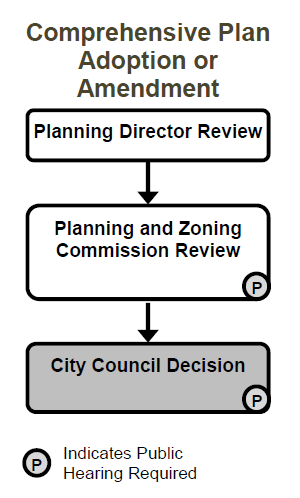
A. Comprehensive Plan Adoption or Amendment. City Council shall adopt a Comprehensive Plan for the orderly development and redevelopment of the City. The Comprehensive Plan shall serve to guide the City Council and the Planning and Zoning Commission in their decisions and recommendations in all land use and land development applications. All applicable provisions of Section 146-5.3 (Common Procedures) apply unless specifically modified by the provisions of this Section 146-5.4.1.A.
1. Applicability. This Section 146-5.4.1.A applies to the adoption of, and all amendments to, the Comprehensive Plan. The provisions of Section 146-5.3.15 (Amendments of Existing Approvals) shall not apply to amendments to the Comprehensive Plan.
2. Procedure.
a. The Planning Director shall review the application and forward a recommendation to the Planning and Zoning Commission pursuant to all applicable provisions of Section 146-5.3 (Common Procedures).
b. The Planning and Zoning Commission shall conduct a public hearing on the application and shall make a recommendation to City Council regarding the application pursuant to all applicable provisions of Section 146-5.3. The Planning and Zoning Commission shall make all recommendations for amendments to the Comprehensive Plan by not less than a two-thirds vote of the entire membership of the Commission.
c. The City Council shall conduct a public hearing on the application and shall make a decision on the application pursuant to all applicable provisions of Section 146-5.3. City Council may approve amendments to the Comprehensive Plan by an ordinance approved by a vote of not less than two-thirds of the entire membership of City Council.
3. Criteria for Approval. A Comprehensive Plan, or an amendment to the Comprehensive Plan, shall be recommended for approval, and shall be approved, only if it promotes the long term economic, social, and environmental health of the City and protects the public health, safety, and welfare of the citizens of Aurora.
B. Annexation and Disconnection. All applicable provisions of Section 146-5.3 (Common Procedures) apply unless specifically modified by the provisions of this Section 146-5.4.1.B.
1. Applicability. This Section 146-5.4.1.B applies to all petitions to annex new land into the City, or to disconnect lands previously annexed to the City.
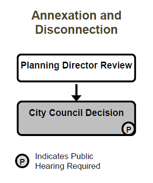
2. Annexation Procedure.
a. Annexation of land into the City shall comply with the procedures and other provisions of Colorado state statutes and approved Three-Mile Plan.
b. Annexation of land into the City shall be consistent with the City’s annexation procedures manual.
c. The final annexation plat shall be provided and shall conform with applicable state statutes. It shall include all information required by the City to evaluate potential impacts of the annexation and whether annexation would promote the public health, safety, and welfare of the citizens of the City.
3. Annexation Policies. Annexation of land into the City is a legislative act of City Council, during which City Council shall consider the following policies.
a. Facilities and Amenities. The City Council finds and determines that certain public facilities and amenities are necessary and must be constructed as a part of any territory annexed to the City so that the public needs may be served by such facilities. These facilities include, but not by way of limitation, major and minor arterial streets, bridges, public parks and recreation areas, school sites, fire and police station-sites, and storm drainage facilities.
b. Cost of Public Facilities. The City Council further finds and determines that the annexation of lands to the City shall be shown not to create any additional cost or burden on the then-existing residents of the City to provide such public facilities in any newly annexed area. No annexation shall be accepted until the City Council, upon the recommendation of the City Manager, determines that the current requirements for such public facilities in the area proposed to be annexed have been fulfilled and that the future requirements for such public facilities can be fulfilled. The annexor shall provide such building schedules, development information, and other data that the City Manager determines to be necessary to establish whether the application meets the requirements of this Subsection b.
c. School Districts. Any annexor shall also show that he or she has negotiated with the appropriate school district for dedication of land or cash-in-lieu of land as may be agreed upon between the parties.
d. Fiscal Impact Analysis. In its consideration of any proposed annexation, City staff shall provide to the City Council an analysis of the fiscal impact of the proposed annexation. The City Council may request additional information or analysis from the annexor. The cost of such additional information and analysis shall be borne solely by the annexor. A fiscal impact analysis shall be valid for one year and may not be used to meet the requirements of this Subsection 3.d for any lands outside the physical boundaries included in the fiscal impact analysis.
4. Disconnection Procedure.
a. The procedure for disconnection described in this Section 146-5.4.1.B is the sole and exclusive procedure for seeking disconnection from the City. It is the intent of the City Council of the City of Aurora to exercise the Home Rule powers granted to certain municipal corporations by Section 6 of Article XX of the Colorado Constitution, to supersede all provisions in C.R.S., Title 31, relating to disconnection.
b. Within 90 calendar days of receipt of an application by the City Clerk, the City Council shall give due consideration to an application for disconnection based on those factors listed in Subsection 5 below.
c. If the City Council finds and determines that the disconnection of such tract will not prejudice the best interests of the City, considering the criteria herein, it shall adopt an ordinance effecting such disconnection.
d. Land disconnected shall not be exempt from the payment of any taxes lawfully assessed against it for the purpose of paying an indebtedness lawfully contracted by the City Council while the land was within the limits of the City and that remains unpaid, and for the payment of which the land could be lawfully taxed.
e. The City Council may by a disconnection agreement establish terms and conditions for granting a disconnection, which terms shall survive the disconnection of the tract of land.
f. An ordinance for disconnection shall be effective as established by the Home Rule Charter. A copy shall be recorded with the county clerk and recorder of the county in which such tract is situated.
5. Disconnection Considerations. Before making a decision on an application for disconnection, the City Council shall consider the following:
a. Whether the tract is situated such that its disconnection would impair extension of roads, utilities, or other infrastructure to other tracts of land located within the City;
b. Whether the tract of land is contiguous to the exterior boundary of the City. Contiguity with unincorporated areas embraced within the limits of the City or enclaves shall not constitute contiguity with the exterior boundary of the City;
c. Whether the tract of land is situated such that its disconnection would impair or preclude future annexations identified in the Comprehensive Plan;
d. Whether the retention of the tract of land within the City would impose a cost for services and infrastructure significantly in excess of the benefit of such tract of land remaining in the City;
e. Whether the disconnection of the property would permit development in a manner that would negatively impact the City or abutting tracts of land that are located within the City;
f. Whether the City is reimbursed for public funds expended on the parcel for infrastructure or other costs;
g. Whether the water rights associated with the land have been received by the City and incorporated into the City's water supply plans;
h. Whether the tract of land is obligated contractually or otherwise expected to participate in the development of a Master Plan or regional infrastructure; and
i. Such other matters the City Council finds relevant to the application.
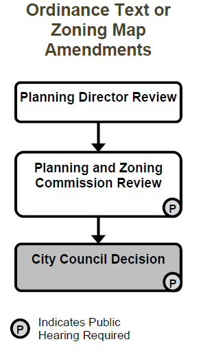
C. Ordinance Text or Zoning Map Amendments. All applicable provisions of Section 146-5.3 (Common Procedures) apply unless specifically modified by the provisions of this Section 146-5.4.1.C.
1. Applicability. This Section 146-5.4.1.C applies to:
a. All applications for initial zoning of property into a base zone district(s), and to initial zoning into an overlay district, if any, at the time property is annexed to the City; and
b. All applications for changes of zoning from one base zone district(s) to a different base zone district(s) following initial zoning into a base zone district; and
c. All applications to include property in, or exclude property from, an overlay district(s), or to change the overlay district(s) that apply to a property; and
d. All applications to change the text of this Unified Development Ordinance.
2. Procedure.
a. The Planning Director shall review the application and forward a recommendation to the Planning and Zoning Commission pursuant to all applicable provisions of Section 146-5.3 (Common Procedures).
b. The Planning and Zoning Commission shall conduct a public hearing on the application and shall make a recommendation to City Council regarding the application pursuant to all applicable provisions of Section 146-5.3.
c. The City Council shall conduct a public hearing on the application and shall make a decision on the application pursuant to all applicable provisions of Section 146-5.3.
3. Criteria for Approval.
a. Initial Zoning and Changes to Zoning Map for Individual Parcels or Small Areas. An application for initial zoning, rezoning, and changes to the Zoning Map for individual parcels or small areas shall only be recommended if the Planning Director and the Planning and Zoning Commission finds that the following criteria have been met, and shall only be approved if City Council finds that the following criteria have been met.
i. The change to the Zoning Map is needed to correct an error (change in the character of surrounding areas does not constitute an error in the map); or
ii. The change to the Zoning Map is required because of changed conditions or circumstances on the property or in the surrounding area and:
(a) The applicant has demonstrated that the proposed initial zoning or rezoning is consistent with the spirit and intent of the Comprehensive Plan, with other policies and plans adopted by the City Council, and with the purpose statement of the proposed new zone district(s);
(b) The applicant has demonstrated that the size, scale, height, density, and multi-modal traffic impacts of the proposed initial zoning or rezoning are compatible with surrounding development or can be made compatible with surrounding development through approval conditions; and
(c) The application demonstrates that the change in zoning will not create significant dislocations of tenants or occupants of the property, or that any impacts are outweighed by other public benefits or progress toward other Comprehensive Plan goals that would be achieved by approval of the application.
b. Ordinance Text Amendments and Legislative Rezoning of Large Areas. An application for an amendment to the text of this UDO or a legislative rezoning of a large area shall only be recommended if the Planning Director and the Planning and Zoning Commission find that the following criteria have been met, and shall only be approved if City Council finds that the following criteria have been met.
i. The applicant has demonstrated that the proposed Ordinance amendment is consistent with the spirit and intent of the Comprehensive Plan and with other policies and plans adopted by the City Council; and
(a) The change to the Ordinance text is required because of changed conditions or circumstances in all or a portion of the City; or
(b) The change to the Ordinance text is required to address a new or unforeseen threat to the public health, safety, and welfare; or
(c) The change to the Ordinance text is required to promote economic growth and investment that will not create material risks to the public health, safety, and welfare.
ii. Non-substantive updates to the text of the Ordinance, including but not limited to updates of hyperlinks or other references to online information related to this UDO, may be approved by the Planning Director and do not require review or approval by the Planning and Zoning Commission or City Council.
c. Approval of Map and Text for a PD Zone District. In addition to meeting the criteria for zoning map and UDO text amendments in Subsection a above, an application for approval of rezoning to a PD zone district shall only be recommended if the Planning Director and the Planning and Zoning Commission find that the following criteria have been met, and shall only be approved if City Council finds the following criteria have been met.
i. The proposed PD is required because of changed conditions or circumstances on the property or in the surrounding area; and
(a) The applicant has demonstrated that the proposed initial zoning or rezoning is consistent with the spirit and intent of the Comprehensive Plan and with other policies and plans adopted by the City Council; and
(b) The applicant has demonstrated that the proposed initial zoning or rezoning is compatible with surrounding development or can be made compatible with surrounding development through approval conditions; and
ii. Any portion of PD zone district to be occupied by single-family detached or single-family attached dwellings shall be divided into blocks with a dimension of no larger than 330 feet by 660 feet with each such block divided from other blocks by local, collector, or arterial streets or freeways; and
iii. Any portion of the PD zone district to be occupied by multifamily, mixed-use, or industrial development shall provide a greater level of internal connectivity and connectivity to surrounding developments than would be required by Section 146-4.5 (Access and Connectivity) if the project were not being developed in a PD zone district; and
iv. When scored against the criteria in Table 4.8-2 (Scoring System for Architectural Features), each single-family detached and single-family attached structure in the PD zone district shall achieve a higher score than would be required if the project were not being developed in a PD zone district; and
v. Each multifamily, mixed-use, or industrial primary structure in the PD zone district shall provide a greater level of design quality than would be required by Section 146-4.8 (Building Design Standards) if the project were not being developed in a PD zone district; and
vi. The PD includes private common spaces that include recreational or community amenities, public art, and/or outdoor gathering spaces for the project residents, occupants and users that exceed those that would be required if the project were not being developed in a PD zone district;
vii. Any lands designed for public park and school sites in the PD zone districts meet the criteria for location of those types of lands in Sections 146-4.3.17 (Parks and Open Space) and 146-4.3.18 (School, Park, and Other Lands for Public Facilities) and any required park and open space lands are designed to connect with similar lands developed or designated on property adjacent to the proposed PD zone district to the maximum extent practicable.
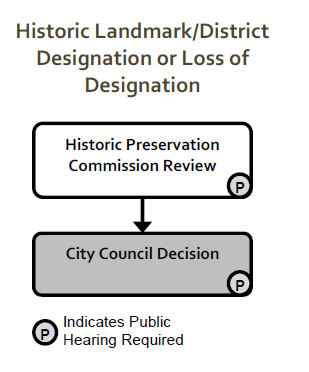
D. Historic Designation or Loss of Designation. The City Council may designate landmarks, landmark sites, and historical districts in the City to accomplish the purposes of this Section. All applicable provisions of Section 146-5.3 (Common Procedures) apply unless specifically modified by the provisions of this Section 146-5.4.1.D.
1. Applicability. This Section 146-5.4.1.D applies to all applications for designation of a historic structure as a City landmark building, and to all applications for designation of an area of the City as a landmark site or historic district. In addition, this Section applies to all applications to remove a structure or an area of the City from the City’s list of designated landmark structures, landmarks sites, or historic districts.
2. Procedure.
a. Designation.
i. A Historic Preservation Commission member, the owner of the property, or any City Council member may initiate consideration by the Historic Preservation Commission of the recommendation for designation of any site as a landmark, landmark site, Cultural Heritage Site, or historic district in writing. The decision to conduct a public hearing shall be approved or denied by a majority of the Commission present.
ii. If a request for recommendation is approved for a public hearing upon the request of someone other than the owner of the property, notice of the proposed recommendation shall be mailed by certified mail to the owner of the property. Such notice shall describe the property affected and provide notice of the date, time, and place at which a hearing before the Commission shall be conducted.
iii. Not less than 30 calendar days following the mailing of notice to the owner, the Historic Preservation Commission shall conduct a public hearing on all recommendations of landmarks, landmark sites, or historic districts.
iv. Following the public hearing, the Historic Preservation Commission shall make a recommendation to City Council based on those criteria in Section 146-5.4.1.D.3. The Commission in its recommendation shall describe the reasons for the decision and provide written notice of the decision to the property owner within 10 calendar days of the hearing.
v. The Historic Preservation Commission shall forward its recommendation to the City Council.
vi. The City Council shall conduct a public hearing on the application and shall make a decision on the application pursuant to all applicable provisions of Section 146-5.3.
vii. The City Council may make available economic incentives to enhance the possibility of designation as an historic landmark, landmark site, or district. The City Council is empowered to receive private or public grants that would enhance historic preservation.
viii. The City Council may amend or rescind its designation of any historic landmark, landmark site, or district. The Historic Preservation Commission shall make a recommendation for such amendment or rescission through the same procedure as was followed in the original designation, including a public hearing.
b. Removal / Loss of Designation.
i. Any person or organization may request in writing the removal of a property from landmark designation by describing the reasons for removal.
ii. In the case of a privately-owned property designated as a landmark, when that property falls into physical disrepair or the historic qualities of the structure are threatened, remedial measures shall be addressed directly with the property owner by the Historic Preservation Commission prior to the removal of landmark designation. Such measures may include help in applicable grant research, aid in the composition of restorative grant applications, or assistance in fundraising for such repairs.
iii. Properties removed from the state register or the national register shall not be considered to have been removed from the City's landmark listing without formal action by the Historic Preservation Commission and the City Council. However, all properties removed from the state register and the national register prior to June 30, 1994 shall be considered to have been automatically removed from City landmark designation.
iv. Requests for removal shall be considered following the procedure in Section 146-5.4.1.D.2.a above.
3. Criteria for Recommendations.
a. Landmarks or Landmark Sites. At the conclusion of the public hearing, the Historic Preservation Commission shall recommend to City Council the designation of a landmark or landmark site, if such structure or site is of particular historical, architectural, cultural, or archaeological significance and:
i. Exemplifies or reflects the broad cultural, political, economic, or social history of the nation, state, or community; or
ii. Is identified with historic personages or with important events in national, state, or local history; or
iii. Embodies distinguishing characteristics of an architectural type specimen inherently valuable for a study of a period, style, method of construction, or of indigenous materials or craftsmanship; or
iv. Is representative of the notable work of a master builder, designer, or architect whose individual ability has been recognized; or
v. Meets specific archaeological criteria as designated by the commission, in accord with federal regulations and community standards; and
vi. Does not deny the owner a reasonable economic use of property.
b. Cultural Heritage Sites. A site and/or structure may qualify for designation as an Aurora Cultural Heritage Site if it meets one or more of the following criteria but lacks sufficient integrity (i.e., it has been significantly altered from its original historic condition) to support its designation as a landmark. Generally, Cultural Heritage Sites are more than 50 years old, but younger sites with exceptional significance to the community may be considered.
i. The property exemplifies or reflects the broad cultural, political, economic, or social history of the community; or
ii. The property is identified with a historic person or historic group significant to local history; or
iii. The property embodies distinguishing characteristics of an architectural type inherently valuable to the study of a period, style, method of construction, or indigenous materials or craftsmanship; or
iv. The property is representative as the work of a master builder or architect; or
v. The property has the possibility to yield important archaeological information.
c. Historic Districts. At the conclusion of the public hearing, the Commission shall make a recommendation to City Council concerning a historic district. The Commission shall determine if the district is an area containing a significant concentration, linkage or continuity of sites, buildings or structures or objects united by past events or aesthetically by plan or physical development. A district may also comprise individual elements separated geographically but linked by association or history, and shall meet the following criteria:
i. A distinguished area that exemplifies or reflects the particular cultural, political, economic, or social history of the community; or
ii. A definite area identified with historical personages, groups or with important events in national, state, or local history; or
iii. A definite area that embodies distinguishing characteristics of an architectural type or style inherently valuable for the study of a period, method of construction, or of indigenous materials or craftsmanship; or
iv. A definite area that, owing to its unique location or singular characteristics, represents established and familiar visual features of the neighborhood, community, or city; or
v. An area that is representative of the notable work of a master builder, designer, or architect whose individual ability has been recognized; or
vi. An area encompassing multiple significant archaeological sites; and
vii. An area that permits reasonable economic use of the owner's property.
d. Recommended Adjustments. The Historic Preservation Commission's recommendation to City Council on a proposed landmark, landmark site, or historic district may include recommendations for exceptions from provisions of this UDO, pursuant to Section 146-5.4.4.C (Historic Landmark and District Adjustments).
e. Removal / Loss of Designation.
i. The property, site, or district has ceased to meet the criteria for landmark designation because the qualities that caused it to be listed have been lost or destroyed, subsequent to nomination and prior to listing as a landmark;
ii. Additional information shows that the property does not meet City criteria for landmark designation; or
iii. Failure to comply with any administrative procedure requirement contained by the nomination or the listing process; or
iv. Continued designation of the landmark, landmark site, or historic district is not in the best interests of the City.
E. Master Plan. All applicable provisions of Section 146-5.3 (Common Procedures) apply unless specifically modified by the provisions of this Section 146-5.4.1.E.
1. Applicability.
a. A Master Plan shall be approved pursuant to this Section 146-5.4.1.E when an application is filed for any of the following:
i. Any area proposed for subdivision of land under common or related ownership or control in Subareas A or B or C;
ii. Any area proposed for development in phases;
iii. Any area where new streets or regional infrastructure will be required to connect to the City’s existing systems;
iv. Any area where multiple parcels of adjacent land require that internal circulation, infrastructure, and open space systems be coordinated to reduce traffic or other impacts on the surrounding area.
b. The Planning Director shall determine the geographical extent and the required components of the various types of Master Plans as defined in any applicable planning development manuals.
c. The Planning Director may authorize simultaneous processing of a Master Plan and other types of approvals required by this UDO if the Director determines that:
i. Compliance with all standards of this UDO and related development manuals can be adequately addressed during simultaneous review; and
ii. It is unlikely that required changes to the Master Plan will require revisions to applications for other types of approvals that would require additional rounds of staff review and inefficient use of staff resources.
d. After a Master Plan is approved, all Site Plans and later development approvals and permits shall only be approved if they are consistent with the Master Plan (except for renovations of existing buildings that do not add gross floor area to the building, and except for additions to existing buildings that add less than 2,000 square feet of gross floor area, unless and until that Master Plan is amended under Section 146-5.3.15 (Amendments of Existing Approvals).
2. Procedure.
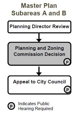
a. Subareas A and B.
i. The Planning Director shall review the application and forward a recommendation to the Planning and Zoning Commission pursuant to all applicable provisions of Section 146-5.3 (Common Procedures).
ii. The Planning and Zoning Commission shall conduct a public hearing on the application and shall make a decision on the application pursuant to all applicable provisions of Section 146-5.3.
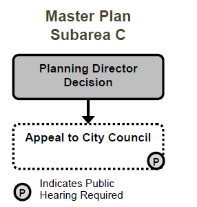
b. Subarea C. The Planning Director shall review the application and make a decision on the Master Plan.
3. Criteria for Approval. A Master Plan shall only be recommended for approval, and shall only be approved, if:
a. It is consistent with the Comprehensive Plan, the purpose statement for the zone district(s) where the property is located, the use regulations in Article 146-3 for the zone district(s) where the property is located, and all other adopted plans and policies of the City Council;
b. It will allow future development of the property to comply with all applicable standards in this UDO;
c. It will result in a coordinated system of streets, trails, sidewalks, open spaces, and infrastructure systems that do not create significant adverse impacts on the surrounding area, or any significant adverse impacts have been mitigated to the degree practicable;
d. It will improve or expand multi-modal connections with adjacent sites, neighborhoods, and urban centers; and
e. If the property is located in Subarea C, and the Master Plan includes over 160 acres of land designated for residential development, the Master Plan must include at least one area to be zoned MU-N or MU-C or designated for development pursuant to MU-N or MU-C zone district standards pursuant to Section 146-5.4.3.I (Administrative Activity Center Designation). (Ord. No. 2019-49 § 1, 08-19-2019)